
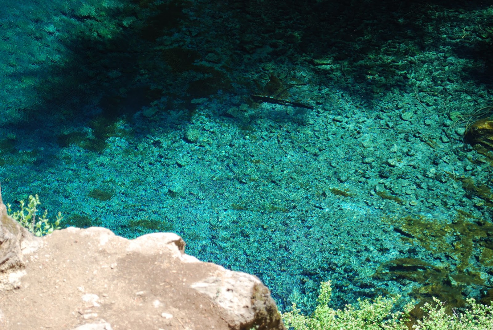
Blue Pool
We couldn't decide where to go for a hike, so we went back to Blue Pool. We did this hike back in 2014. We really liked it. I was bummed because we didn't see a waterfall then. The book shows a picture of a waterfall, but apparently there's a dam that makes it so there's no more waterfall.

The hike itself is pretty easy, but the terrain is a bit rocky. I kept tripping over rocks. We decided not to bring our poles since we both remembered it being a fairly easy hike, but I was kind of regretting not having my poles because I almost went face first a few times. I never did actually fall, but there was at least one time that I thought I was going to end up landing on my hand and that was going to hurt. I might need to start wearing gloves when I hike. My skin is so sensitive and I'm such a wimp when it comes to bruises.

The parking lot isn't that big for this hike, but there's a lot of space that people turn into parking spaces on the road. This is a very popular hike. Bikes can also go down this path. I don't think they can go up it though. I'm not really sure of the whys on that, but I think those are the rules We had to pull over a lot to let bikes pass and several times to let people pass since the path isn't really wide enough for groups of people to pass each other. We got a late start on the hike too so a lot of people were coming down as we were going up.

There are two bridges on this trail. They can be a bit slick so be careful. I'm not sure how many feet in elevation this hike has because both of my apps differ and they different from the book as well. I do remember going up this thing thinking that I shouldn't have found this hike to be Easy back in 2014. It wasn't hard, and I had no problems with it this time, but two years ago, I feel like I would have found considered it Easyish which means easy for fit people and a little challenging for those of us who are 100 pounds over weight. This time around, we didn't stop to take a breather going up. We stopped for pictures, but we never stopped because we just couldn't continue anymore. I guess that should be considered easy.

The terrain made it a bit tiring though. Way too many rocks to trip over. There was also a big tree that had fallen over the path. People had made their own path around the tree, but going over the tree wasn't really an option for us. The path around the tree was easy enough on the way up, but on the way down hubby had to help me a little bit. So the giant tree fell over the main path, but there was also a small tree or a branch off the big tree I'm not sure which that you had to climb over to get back out. On the way up, it's just a giant step down. Down is a lot easier than a giant step up since gravity helps you go down and it doesn't hep you go up. I took too long trying to decide if I could do it so hubby just stuck his hand on my butt and pushed. I kinda wanted to see if I could do it on my own, but that's what I get for taking too long.

Overall, this is a great hike. I wouldn't go wearing flip flops and I wouldn't take toddlers unless you've got them in some sort of carrying device, but it's an awesome hike. There were people jumping into the pool while we were there which created some extra entertainment. If you want pictures without people in them, you might want to get there super early. We've been twice though and both times people were on the ground by the pool. If you want to get down there, you either have to jump in, or you can keep going past the pool and then follow a trail around the pool and then down to the pool level. We didn't do that. We'll probably do that the next time we are there.

Polar M400 Screen Shots
I forgot my heart rate monitor at home, so it's just the GPS stuff this time. I'm pretty sure the elevation is a bit screwed up on this since I know we didn't go 840 feet up.


 |
| I'm not really sure why this looks like it does. That spike at the halfway point shouldn't be there and the beginning part should look more like the end part or the end like the beginning since it was an out and back. This is what drives me crazy about all of these devises! |
Gaia GPS
Here are the screen shots from Gaia GPS. The elevation looks a little bit more realistic on this one. However, it still shows that I went up higher than I came down, but it was an out and back. I walked up and then I walked down. It should be the same up and down. The max speed of 8.1 is not accurate either. I can't even run that fast.


No comments:
Post a Comment